
Artificial intelligence is changing the way investigators study online content, and visual intelligence is becoming one of the fastest-growing areas in this space. A large amount of useful information now comes from photos and videos shared across social media, messaging platforms, drones, and public websites. In response to this shift, TraceX Labs has introduced GEOX AI, a platform focused on identifying the location of visual content through artificial intelligence and geospatial analysis.
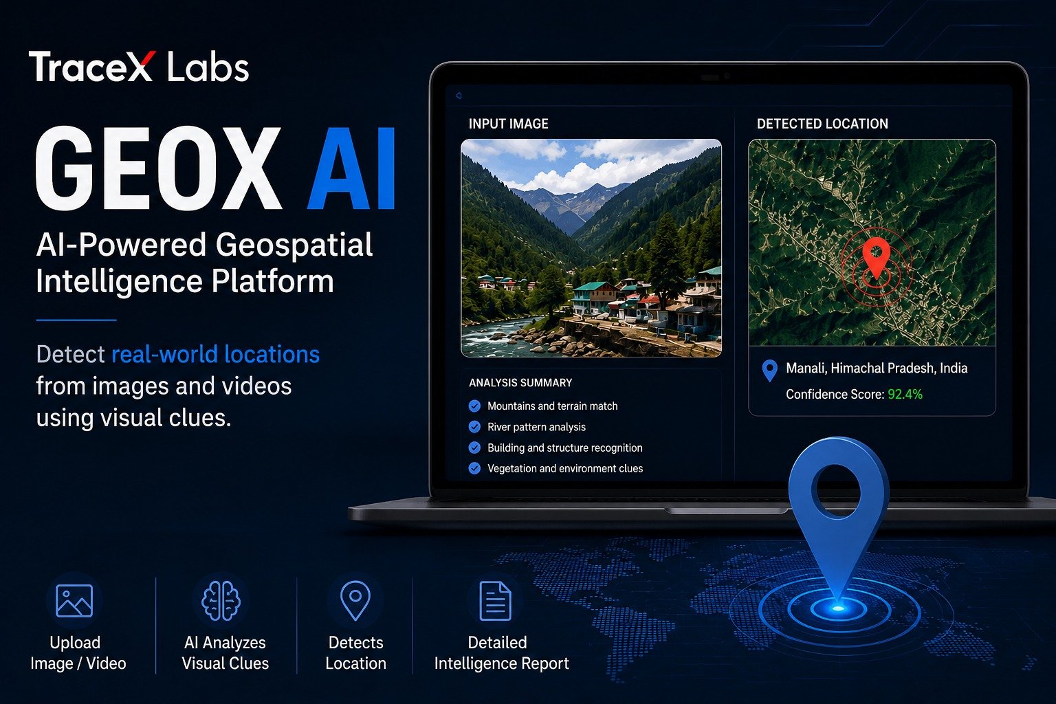
What makes GEOX AI interesting is that it does not depend entirely on GPS coordinates or hidden metadata. In many cases, uploaded media no longer contains EXIF data because social platforms often remove it automatically. This creates a challenge for investigators who rely on traditional geolocation methods. GEOX AI attempts to solve that problem by examining what is visible inside the image itself.
The platform studies environmental details that most people would normally ignore. Roads, buildings, terrain, weather conditions, shadows, vegetation, and regional infrastructure all become part of the analysis process. By combining computer vision with machine learning models, the system tries to estimate where a photo or video may have been captured.
TraceX Labs says the technology is built for a wide range of professional use cases. Cybersecurity teams can use it during digital investigations, journalists may apply it for content verification, and intelligence analysts can study conflict footage or suspicious online activity. The company also points toward applications in disaster response, military reconnaissance, misinformation tracking, and forensic investigations.
One of the stronger aspects of GEOX AI is its layered analysis approach. Instead of generating a simple result, the platform reportedly produces confidence scores, reasoning reports, and geographic probability estimates. Users can review how the AI reached its conclusions rather than relying on a completely hidden decision-making process. Interactive mapping tools are also included to compare uploaded visuals with surrounding geographic regions.
The platform currently offers two separate investigation modes. Fast Mode is designed for quick verification tasks where speed matters most. Advanced Mode takes a deeper approach and performs more detailed environmental analysis, especially when dealing with low-quality visuals or limited contextual information. This could be useful in situations where even small details become important.
The rise of AI-powered geolocation tools is also raising new privacy concerns. Many users assume that removing GPS metadata is enough to hide their location online. However, modern AI systems are increasingly capable of extracting location clues from environmental details alone. Elements like sunlight direction, architecture styles, road markings, or even local vegetation can sometimes reveal more information than people expect.
Experts believe visual intelligence technology will continue evolving quickly over the next few years. Future systems may support real-time geolocation, automated drone intelligence, advanced satellite integration, and faster battlefield analysis. As online visuals continue to grow across every digital platform, tools that can interpret geographic clues are likely to become more important for governments, security teams, researchers, and investigative agencies.
GEOX AI reflects a broader shift happening in modern intelligence gathering. Images and videos are no longer just content for viewing. They are increasingly becoming data sources that artificial intelligence can analyze for actionable insights.


